
The Changing Dynamics of Rural Landscapes
Exploring the Cascading Effects on Ecology, Climate, and Migration in the Wake of Urbanization.
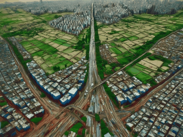
This research investigates how urban sprawl and infrastructure corridors are transforming India’s rural landscapes, triggering cascading impacts on ecology, climate risk, and cultural continuity. As road networks expand, they fragment watersheds and convert fertile agricultural land into chaotic, unplanned development, a phenomenon known as Desakota. This shift matters globally: with India housing 18% of the world's population on just 2.4% of its land, local land-use decisions aggregate into significant climate consequences.
The study combines multi-layer geospatial analysis with policy design to identify where growth conflicts with ecological systems. By integrating spatial datasets including watersheds, soil fertility, and biodiversity, the research generates "conservation priority maps" that highlight areas essential for long-term resilience.
This framework is tested in the coastal corridor between Mangaluru and Udupi along NH66. Here, rapid urbanization is merging villages into a continuous semi-urban strip. The project proposes shifting from this sprawling growth toward planned "Rurban Clusters", strategic nodes that centralize development while protecting the surrounding agrarian and ecological fabric. The outcome is a scalable model for balancing India’s infrastructure needs with environmental sustainability.
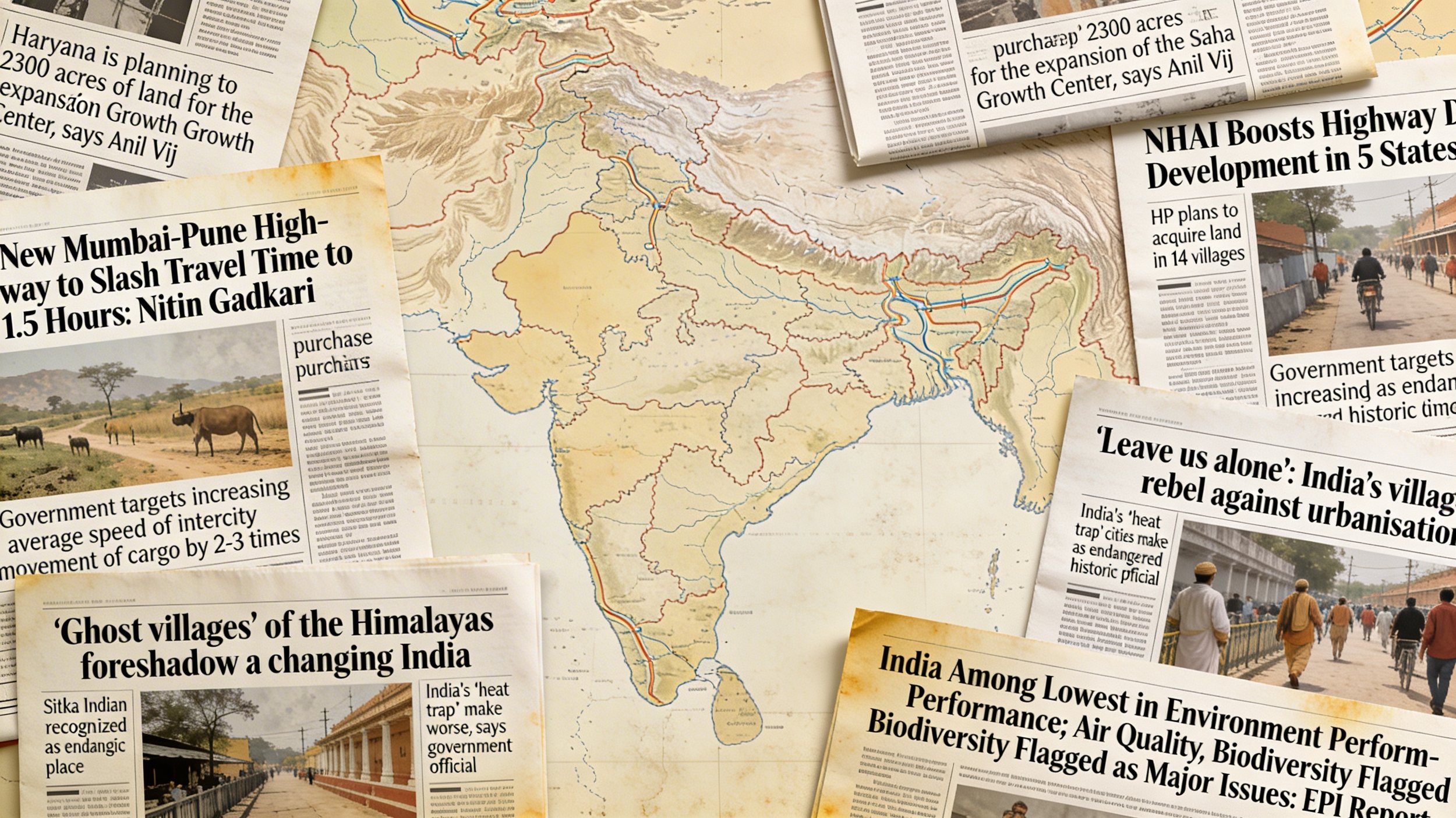
India's development strategy has prioritized urbanization and infrastructure expansion—particularly road networks connecting urban centers. This has triggered significant environmental consequences: Indian cities are warming at nearly twice the rate of surrounding regions, with urbanization contributing approximately 60% of overall urban temperature increases. Heat islands, flooding, air pollution, and ecosystem disruption now define many metropolitan areas.
Meanwhile, as highways cut through rural landscapes, they disrupt traditional agricultural communities and erode cultural practices that historically promoted sustainable resource management. The socioeconomic divide between urban and rural India continues to widen—cities gain economic momentum and services while rural areas face declining agricultural viability, prompting widespread migration.
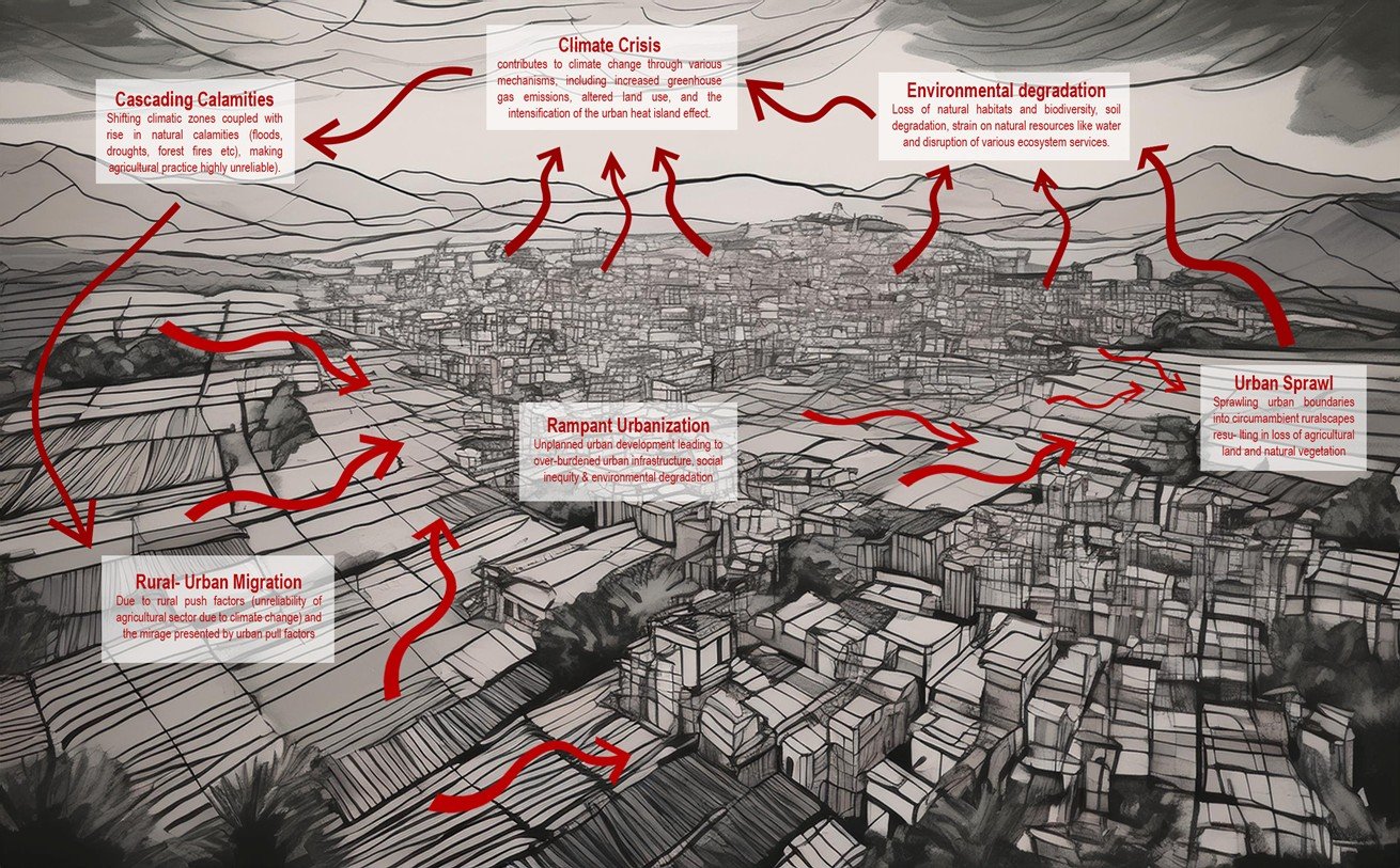
This creates a self-perpetuating cycle: rampant urbanization leads to environmental degradation and climate stress, which in turn drives rural-urban migration, fueling further unplanned sprawl. The cascading effects, shifting climate zones, natural disasters, unreliable agricultural conditions, and cultural desolation—make addressing this pattern essential for India's sustainable future.
How does the interplay between urban sprawl and infrastructure development in India impact rural landscapes, and what are the cascading effects on environmental degradation, climate change, cultural desolation, and migration patterns?
What recommendations can be made for policymakers and planners to address the interconnected challenges of environmental degradation, climate change, cultural desolation, and migration in India’s urbanizing rural landscapes?
How can the findings from the Mangalore-Udupi case study be extrapolated to develop sustainable urban planning policies for other regions in India?
How can the integration of conservation priority maps and urban growth patterns inform policy decisions to balance development needs with environmental preservation?
What innovative urban design and planning approaches could be implemented to promote more sustainable urban growth in India?
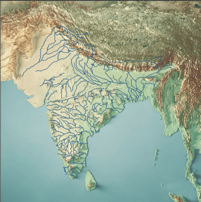
To assess the conflict between ecological preservation and urban expansion, this study employs a multi-layered geospatial analysis at the national scale. Using GIS technology, distinct ecological datasets, including natural watersheds, biodiversity-rich forests, and fertile agricultural zones, are synthesized to create a comprehensive "Conservation Priority Map" that identifies regions critical for ecological integrity. Concurrently, an "Urban Growth Layer" mapping existing megalopolises and emerging secondary cities is developed. By overlaying these urban patterns onto the conservation map, the analysis reveals critical zones of friction where infrastructure-led sprawl threatens sensitive ecosystems, providing a macro-level framework to evaluate the sustainability of India's current development trajectory.
Visualizing the Analysis:
Map of India showing topographic landforms and the watershed system across the country. This becomes the base map to develop the conservation map.
Overlaying the natural forest map on the base map, second layer of conservation map on the National scale.
Overlaying the cultivable soil map on the base map to create the conservation mapat the National scale, clearly delineating "no-go" zones for heavy industrialization.
Mapping the "Urban Flux" by plotting major megalopolises (black dots) and emerging secondary cities (red dots) to visualize the current trajectory of urbanization and performing the critical overlay analysis by superimposing the urban growth layer onto the conservation map, exposing exactly where sprawl is encroaching upon ecologically sensitive regions.
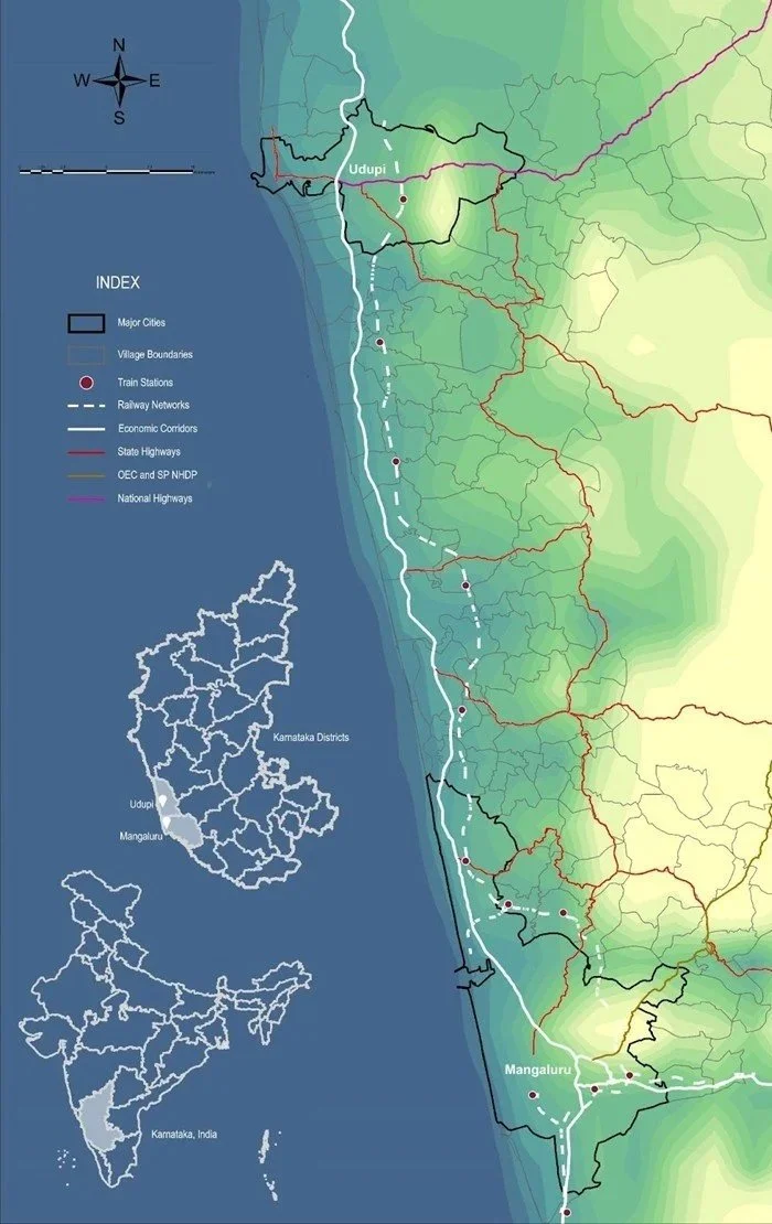
Now India is a huge country, with every city posing its own set of complexities, I decided to streamline my research by directing my focus on the coastal corridor encompassing the young cities Mangaluru and Udupi in Karnataka, along the West coast of India.
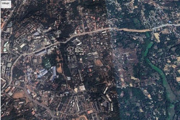
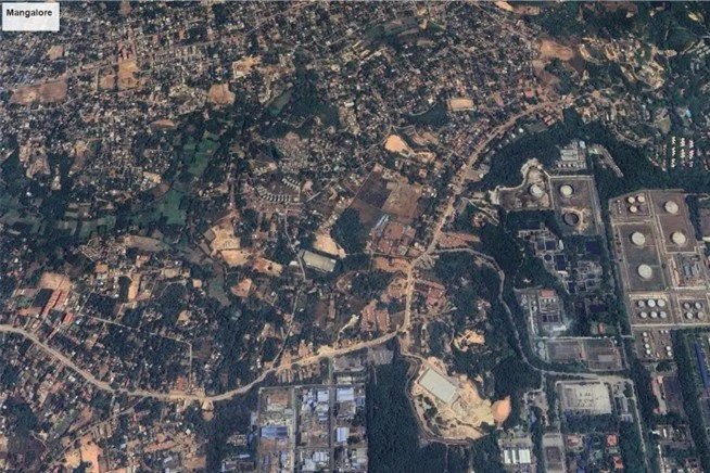
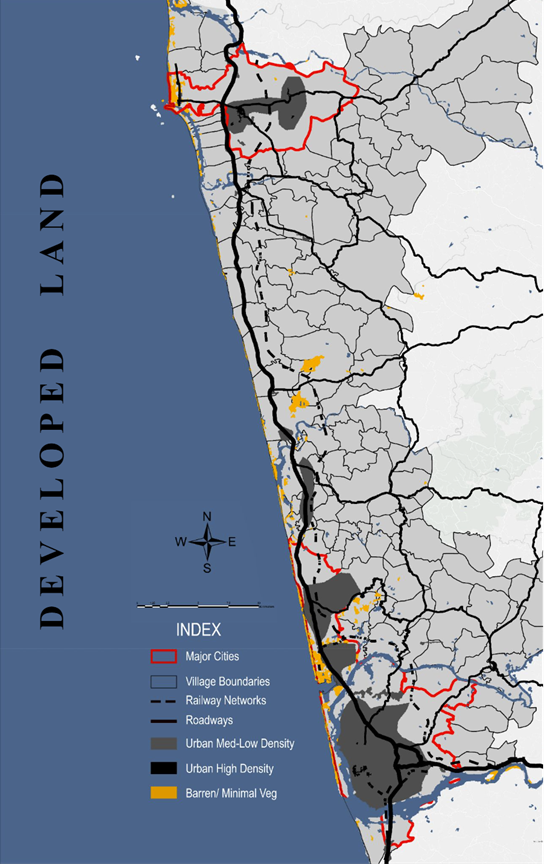
Both Mangaluru and Udupi are growing unplanned cities along the Western Coast of India. Mangaluru emerged as a major industrial and educational hub due to its port and industries, and Udupi grew as an educational hub due to the establishment of Manipal University. This industrial and educational status led to the rapid growth of both these cities into urban agglomerations - this rapid urbanization and lack of incentives from the planning authorities led to the organic growth of both cities. In addition to that, they lie at the intersection of the Western Ghats, which are the hill range along the west coasts of India, and the coastal plains. This topography further makes urban planning, especially transport infrastructure, challenging.
As the Cities continue growing in economic importance, NH66 becomes an important economic corridor along the west coast connecting these two urban centers. As a result of this, the villages in between these two agglomerations that were initially predominantly agriculturally inclined are slowly turning their backs on agriculture and shifting towards the industrial and service sector, facilitated by the establishment of this economic corridor. This is leading to the development of urban trends along NH66, leading to the organic sprawl of the two major urban centers, while at the same time, sporadic development of intermediate semi-urban centers. This will have cascading effects on the local economy, society, and culture on the micro level, and the environment and climate on the macro level.
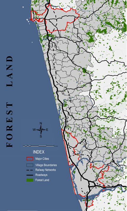
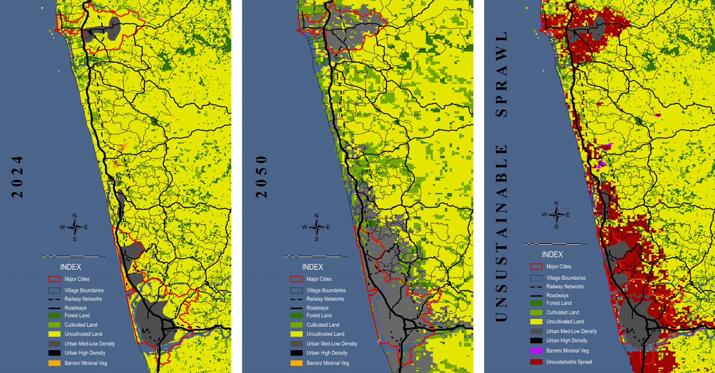
The Mangaluru-Udupi corridor serves as a critical microcosm for analyzing the broader patterns of urban-rural interaction across India. Through advanced geospatial techniques, this phase of research maps the region’s complex sprawl patterns to reveal the long-term unsustainability of current development trends. The analysis begins by isolating key ecological layers: intricate watershed systems, biodiversity-rich forests, active cultivation zones, and fertile grasslands capable of supporting either reforestation or agriculture.
These individual layers are synthesized into a Comprehensive Conservation Map, which strictly delineates areas where urban expansion would be ecologically destructive. Conversely, a separate analysis maps existing urbanization trends alongside barren or uncultivable lands—areas where development would exert minimal environmental stress. By overlaying these "no-go" conservation zones with "low-impact" growth zones, the multi-layered approach identifies precise opportunities for sustainable expansion. This nuanced mapping provides a data-driven foundation for regional planning, ensuring that future growth is directed away from sensitive ecosystems and toward lands best suited to support it.
By integrating three distinct ecological layers, a Comprehensive Conservation Map was generated to strictly delineate areas where urban sprawl is ecologically unsustainable. This was analyzed alongside a Developed Land Map, which illustrates prevailing urbanization patterns, and a map of barren or uncultivable regions—spaces where construction would exert minimal environmental impact.
This multi-layered approach isolates "low-impact" development zones from sensitive ecosystems, providing a nuanced understanding of the region's capacity. The resulting framework enables informed, data-driven decision-making, ensuring that future regional planning directs growth toward suitable lands while preserving critical natural resources.
The Mangaluru-Udupi corridor perfectly embodies the Desakota concept, a unique spatial phenomenon where rural and urban characteristics intensely blend along transport corridors. Unlike traditional peri-urban zones, these regions feature a chaotic mix of agriculture, industry, and commerce driven by rapid economic globalization, with even major urban centers like northern Mangaluru and Udupi exhibiting this random, unplanned collage of land uses. These hybrid landscapes, bridging rural-urban divides, serve as critical microcosms for observing ecosystem stress, underscoring the urgent need for structured planning where formal and informal sectors collide.
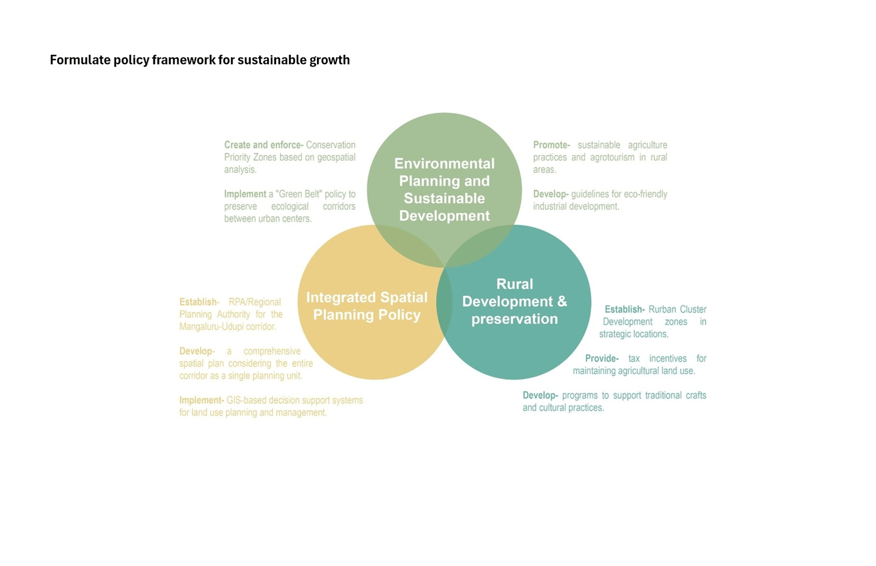
The whole region, including the cities, falls into the category of Desakota, just with varying degrees of rural and urban characteristics, leading to very chaotic land-use patterns, and if the current urban trends persist, the chaos will only worsen in terms of ecology, connectivity and governance. To avoid that, I tried to create a policy framework to make a shift from Desakota to Rurbanism. Rurbanism is a planned approach to integrate urban amenities with rural characteristics, aiming to create sustainable development patterns that preserve rural identity while providing modern infrastructure and services. It represents a deliberate planning strategy that seeks to balance urbanization with rural preservation through policy frameworks and intentional interventions.
Proposed Intervention: The Rurban Cluster Model
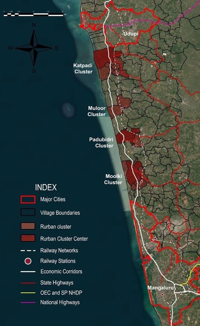
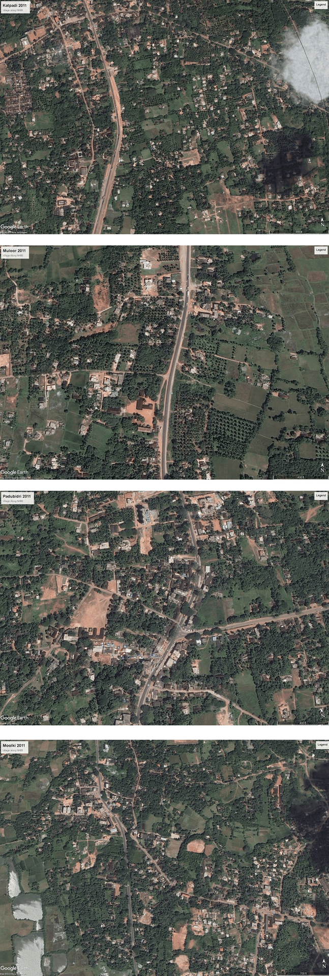
To counteract the chaotic sprawl of the Desakota corridor, this research proposes a shift from continuous linear development to a Rurban Cluster Model. By identifying four strategic nodes—Katpadi, Muloor, Padubidri, and Moolki—situated at critical intersections of NH66 and state highways/railways, the framework channels growth into compact, self-sustaining centers.
These clusters are designed as intermediate settlement hierarchies that provide urban amenities (healthcare, education, markets) while maintaining the rural ecological fabric. Instead of letting the highway consume the entire countryside, development is densified within these specific 25,000–50,000 population nodes, preserving the agricultural hinterlands in between.
Key Benefits:
Ecological Preservation: Protects contiguous green belts and watersheds from fragmentation.
Migration Mitigation: Creates local economic hubs, reducing distress migration to overcrowded cities.
Efficient Infrastructure: Focuses public investment on specific nodes rather than stretching resources along an endless highway strip.